

Severe Weather Update: Extreme Cold Front Will Bring Thunderstorms, High Winds & Coastal Flooding
Update Friday Dec 21, 18 10:20 am:
WEATHER ALERT UPDATE FROM THE NATIONAL WEATHER SERVICE (Friday morning):
A gale warning is in effect for all #FloridaKeys coastal waters today and tonight.
A coastal flood advisory also is in effect for the bayside of the Upper Keys (Key Largo, Islamorada and Tavernier) today through Saturday morning.
A wind advisory is in affect today for all of the Florida Keys, with expectd west winds sustained at 25 to 30 mph and with frequent gusts of 35 to 40 mph, according to the U.S. National Weather Service (NWS).
While this morning’s low tide is making water levels not too impressive along the Lower and Middle Keys this morning, large swells (measured 19 to 22 feet at a few buoys this morning in the open Gulf of Mexico) are heading toward the west Florida Shelf.
These swells, in combination with the west winds and a steady rise in Florida Bay, will cause significant flooding on Bayside neighborhood streets in the far Upper Keys. The flooding is expected to be about 1 to 2 feet water depth over the lowest streets, yards and docks. The water levels will be highest in the Upper Keys this evening after sunset with only slow improvement through Saturday morning.
It also will cause some minor coastal flooding, similar to noticeable King tides, on the Gulfside/Bayside in the Lower and Middle Keys. This will occur as high tide approaches later this afternoon and early evening.
For those in the risk areas, you still have time to move any personal items, outdoor furniture and the like that could possibly flood to higher ground.
On Thursday night, with the exception of a couple strong thunderstorms out in the Florida Straits, the strongest thunderstorm-related wind gusts measured near the Keys was 45 mph.
———-
December 20, 2018
A vigorous cold front will hit the Florida Keys late Thursday afternoon and evening. A gale warning also is in effect for all of the Florida Keys coastal waters.
Multiple weather hazards are possible:
A few severe thunderstorms with damaging wind gusts of 60+ mph are expected late this afternoon and evening
Strong sustained winds of 25 to 30 mph with gusts near 40 mph are expected this afternoon through Friday early evening
Coastal flooding on the Gulf/Bayside. The highest levels will be on the Bayside in the Upper Keys and are expected to occur tonight through Saturday morning
While winds will decrease rapidly by Saturday morning, coastal flooding may linger through Saturday morning in the far Upper Keys.
Now is a good time to secure any furniture and other items outside the house and move items that possibly could flood to higher ground.
Please stay off the roads during the severe thunderstorms, when high winds can cause problems, especially while traveling on bridges.
RAINFALL:
At this time, total rainfall from tonight through Friday is expected to be generally 1 to 2 inches, with a few locations receiving higher amounts. While it is possible brief periods of street flooding may occur, the main concern with rainfall will be coincident with any strong to severe thunderstorms, which may damage homes and businesses structures still awaiting permanent roof replacements/repairs.
COASTAL FLOODING ON GULFSIDE/BAYSIDE
TIMING
Lower & Middle Keys: Late this evening through early morning hours Friday near high tide, then again Friday afternoon near the next high tide.
Upper Keys: Beginning after midnight Friday night, then peaking Friday afternoon and evening, and receding below flood levels Saturday afternoon.
IMPACTS
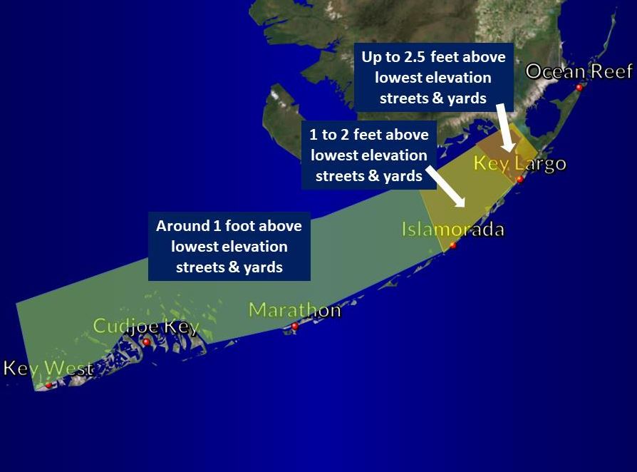
Extreme Upper Keys: Peak water levels approaching 2.5 feet depth over lowest streets and yards, including Jewfish Creek area properties and bayside Key Largo communities. Some neighborhood streets may be impassible.
Remainder of Upper Keys: Peak water levels 1 to 2 feet in depth over lowest streets and yards on the bayside. Some neighborhood streets may be impassible.
Middle and Lower Keys including Key West: Peak water levels up to 1 foot over lowest street and yards on the Bayside/Gulfside. Streets should mostly remain passable; ‘no wake’ driving rules may apply where homes and businesses are not elevated.
For additional information from the National Weather Service:
https://www.facebook.com/NWSKeyWest

Facebook Comments