

TROPICAL STORM FORCE WINDS EXPECTED TO STRIKE UPPER KEYS EARLY THURSDAY
MONROE COUNTY — A Tropical Storm Warning is in effect for the Upper and Middle Keys, with impact from Hurricane Matthew expected to hit Monroe County a little later than originally forecasted. Impacts now are expected to begin in the Keys just before sunrise Thursday and continue through Thursday night.
The highest winds are expected between noon and 6 p.m. Thursday, said Florida Keys National Weather Service meteorologist Jon Rizzo.
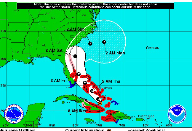
As of Wednesday morning, Hurricane Matthew dropped from a Category 4 to a Category 3 storm at 115 mph. It is located about 440 miles southeast of Key Largo and moving north northwest at 10 mph. But forecasters predict the storm will strengthen.
The Tropical Storm Warning is in effect for Florida Bay, the Gulf waters north of the Middle Keys, and the Florida Straits east of the Middle and Upper Keys, including Hawk Channel.
Ocean Reef, at the northeast section of Monroe County, is at the highest risk of the storm’s impact. The community is now at a 62 percent chance of sustained tropical force winds (greater than 39 mph). Islamorada is at a 42 percent chance, with Marathon at 29 percent and Key West at 16 percent.
Residents and visitors in the Upper Keys, including Ocean Reef, should prepare for tropical storm force winds. Those in the Middle Keys can expect winds of 20 to 30 mph with gusts of 35 mph. For the Lower Keys, winds of 15 to 25 mph are expected, with gusts to 30 mph. Winds will be coming from a north to northwest direction.
“There can be little brief squalls, like thunderstorms racing through, that can bring winds of 40 mph or a little stronger,” Rizzo said.
The entire Keys is at a low risk for hurricane force winds, according to the National Weather Service.
Minor coastal flooding is expected Thursday through Friday throughout the Keys. On the bay side of the Upper Keys, the high waters may not recede until Saturday.
Local heavy rainfall is possible Thursday through Friday. Minor, localized flooding could occur in the normally affected low lying areas. General rainfall totals are expected of 1 to 3 inches, with isolated amounts up to 5 inches possible for the Upper Keys.
Monroe County Administrator Roman Gastesi said the County will wait until the 11 o’clock weather advisory to make any decisions regarding protective measures for the County. Monroe County School Superintendent Mark Porter said he also will wait for the 11 o’clock advisory before deciding on any school closures for Thursday.
Monroe County Emergency Management Director Martin Senterfitt said no evacuations are planned for the Keys.
To receive Monroe County Emergency Management news and informational updates by text message on your phone or by email, go to Monroecountyem.com and click on big red Alert button and fill in the information.
Now is the time for you to prepare for any possible impacts that could occur due to heavy rain, possible high winds and possible localized flooding. For more information on preparedness, go to:http://www.monroecountyem.com/index.aspx?NID=90.
Facebook Comments