

WHERE THE HECK IS THE SOUTHERNMOST POINT?
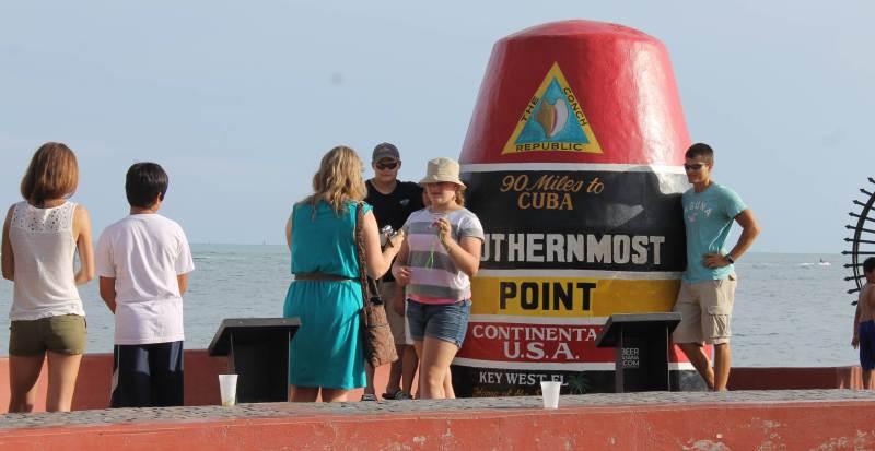
The Southernmost Point. That big red buoy at the southern end of Whitehead Street. One of the top tourist attractions on the island. But most Key Westers know that the big red buoy does not really mark the actual geographic Southernmost Point. The actual Southernmost Point is supposedly a few blocks on the other side of that fence on Navy property, right? But if the buoy were placed over there, very few tourists would be able to go there and get their photo taken. What most Key Westers may not know, however, is that the actual geographic location of the Southernmost Point in the contiguous 48 states is not over on Truman Annex either. It’s on the reef, six miles out into the Atlantic– Western Dry Rocks. From a tourism standpoint, that location is not only more inaccessible than the Truman Annex location, it is only above water at low tide. But, at least, the Truman Annex location is still the Southernmost Point in the contiguous 48 states that is continuously above water. Right?
Wrong. Ballast Key, a privately-owned 26-acre island located nine miles southwest of Key West, is further south than either the red buoy or Truman Annex. This island is officially the Southernmost Point in the contiguous 48 states that is continuously above water. But this posh estate is not accessible to tourists either– although it has been a vacation retreat for major and minor celebrities for years. It was even featured in the James Bond movie “License to Kill.” But, actually, you might be able to live there, if you can afford it. The island is being advertised for sale on the internet for a mere $15.8 million.
So, accessibility and sea level explains the municipal decision back in history to locate the Southernmost Point monument at the end of Whitehead Street– as well as the decision to ignore the challenge to advertise the attraction as The Southernmost Point in the Contiguous 48 States That is Not Only Accessible, but is Also Continuously Above Water.
Before 1959, when Hawaii became a state, Key Westers did not have to qualify the “southernmost” label with the “in the contiguous 48 states” add-on. But after statehood, Hawaii preempted the southernmost designation. South Point, on the south tip of Hawaii’s Big Island, is now the official Southernmost Point in all of the 50 states. But say what you want about the big red buoy, it is located in an historic city that is fun to visit– and you can drive or walk to the monument and there is usually a place to park. South Point in Hawaii is very remote, several miles from the nearest town. The wind blows all the time and, in fact, is so unrelenting that many of the trees grow almost horizontal. A confluence of currents makes swimming extremely dangerous. In fact, it is called the “Halaea Current,” named after a chief who was carried off to his death. The confluence of currents also means that the area is prone to accumulation of marine debris– and the remoteness makes clean-up difficult. Few tourists make the effort to visit South Point in Hawaii.
While Hawaii boasts the Southernmost Point in the 50 United States, it is not the extreme southernmost point of all United States territories. That point lies on the Pacific Island of American Samoa which is located south of the equator in the Southern Hemisphere. But even Samoa is not the Southernmost Point under United States control. Did you know that there is a U.S, government research complex at the geographic South Pole, the Southernmost Point on Earth? This research facility has been in continuous operation since 1956. Since it is located at the South Pole, the sun stays “up” for six months and “down” for six months. In essence, a year there consists of one long day and one long night. The population there is about 200 people in the “summer” and about 50 in the ”’winter.” The facility has been in the news in recent days. One of the scientists apparently suffered a stroke and the weather– a dark and stormy 72 degrees below zero — has made it difficult to fly in to rescue her.
When I began to research this story, one of the things I wanted to do was to determine the truth or falsehood of a rumor I had been hearing for years– that the City of Brownsville, located at the southern tip of Texas, is further south than Key West. It’s not. Brownsville is located at Latitude 25/90. Key West is located at Latitude 24/32. If on a map you draw a line on Latitude 25/90 from Brownsville across the Gulf of Mexico, the line will cross Florida somewhere in North Miami. Consider that rumor debunked.
NORTHERNMOST POINT
As long as we’re at it, what are some of the other extreme geographic points in the United States? Like South Point in Hawaii, the Northernmost Point in the contiguous 48 states is very remote. It’s a place called Northwest Angle, located at the top of Minnesota– but not connected to the state by land. It is located on the Canadian side of Lake of the Woods. To get there by car, you have to cross the Canadian border into Manitoba and go through Canadian customs– and then drive for miles on roads that are sometimes unpaved– and then cross the border again, and clear U.S. customs by videophone– then drive a few more miles on bad roads to the township of Angle Inlet (population 116). In addition to a general store, a one-room schoolhouse and the police station, you will see a sign that tells you that you’re at the “Top of the Nation.” That’s it. Of course, you can avoid the drive through Canada by crossing the lake by boat or plane. Or, in the winter, when the lake freezes over, you can drive across the ice– if you want to risk that.
The Northernmost Point in the entire 50 states is located at Point Barrow, which is located at the very top of the State of Alaska, 350 miles north of the Arctic Circle. The residents of the nearby city of Barrow (population 4000) brag as much about being the “Land of the Midnight Sun” as they do about being the northernmost city in all of the United States and territories. In this part of the world, for two months during spring and summer, the sun never sets. The North Pole is not a competitor for the Northernmost Point under U.S. control because there are no facilities there, research or otherwise. The geographic North Pole is located in the middle of the Arctic Ocean, where there is no land, only drifting ice.
WESTERNMOST POINT
The Westernmost Point in all 50 states is also in Alaska, but the exact place is somewhat controversial– because what you might think of as the westernmost island in Alaska’s Aleutian chain of islands is on the other side of the International Dateline and, therefore, is considered “East.” So the westernmost island in the Aleutian chain could technically be considered the Easternmost Point in the United States. Got that? In any event, the Westernmost Point in all U.S. territories is the Pacific island of Guam.
The Westernmost Point in the contiguous 48 states is Cape Alava, in the State of Washington. Like South Point in Hawaii and the Northernmost Points in Minnesota and Alaska, Cape Alava is remote. It is located on an Indian reservation in a state park, a three-mile hike from the ranger station.
EASTERNMOST POINT
The Easternmost Point in all U.S. territories is on the island of St. Croix in the U.S. Virgin Islands. The Easternmost Point in the contiguous 48 states is West Quoddy Head in the small town of Lubec, Maine. There is a tombstone-looking monument in Lubec noting that designation. I was not able to determine if tourists ever line up to have their photo taken beside the tombstone.
The former publisher is a treasurer of useless (but fascinating) facts and needless (yet interesting) information.
It is just one more misleading facts that Key West uses on tourist. Similar to telling people that Hemingway drank at Sloppy Joes. He did but it is Captain Tony’s now. The truth is often gray.